
Advisories (25)
Issue Date: 31 October, 2025 11:03 AM |
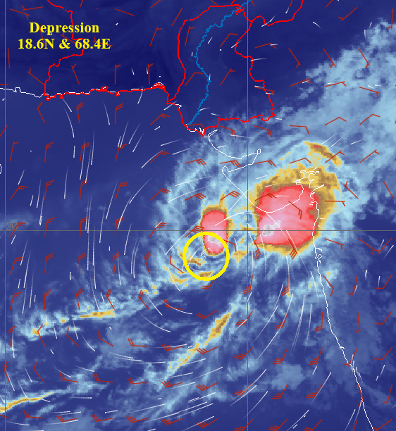
Depression over eastcentral Arabian Sea
The Depression over eastcentral Arabian Sea moved north-northeastwards during past 24hours and now lay centered around Latitude 18.60N & Longitude 68.40E at about 712Km south-southeast of Karachi and 330Km southwest of Veraval, Gujrat (India).
It is likely to move nearly north-northeastwards across eastcentral Arabian Sea during next 24hours and weaken gradually thereafter.
Currently, there is no threat to any Pakistani coastal area. PMD’s cyclone warning center, Karachi is monitoring the system and will keep the relevant quarters abreast.
Issued By: Tropical Cyclone Warning Centre, Karachi
Issue Date: 30 October, 2025 11:02 AM |
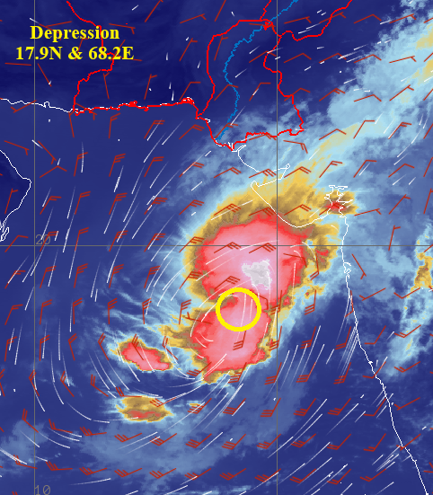
Depression over eastcentral Arabian Sea
The Depression over eastcentral Arabian Sea moved westwards during past 24hours and now lay centered around Latitude 17.90N & Longitude 68.20E at about 786Km south-southeast of Karachi and 400Km southwest of Veraval, Gujrat (India).
It is likely to move nearly westwards across eastcentral Arabian Sea during next 24hours.
Under its influence light rain/drizzle may occur at isolated places in Tharparker District.
Currently, there is no threat to any Pakistani coastal area. PMD’s cyclone warning center, Karachi is monitoring the system and will keep the relevant quarters abreast.
Issued By: Tropical Cyclone Warning Centre, Karachi
Issue Date: 29 October, 2025 11:07 AM |
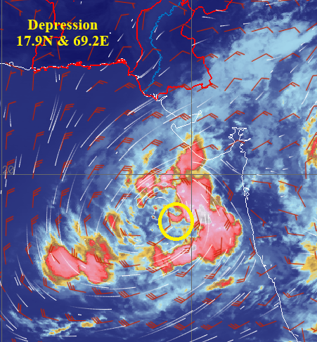
Depression over eastcentral Arabian Sea
The Depression over eastcentral Arabian Sea moved northeastwards during past 24hours and now lay centered around Latitude 17.90N & Longitude 69.20E at about 810Km southeast of Karachi and 430Km southwest of Veraval, Gujrat (India).
It is likely to move nearly northeastwards across eastcentral Arabian Sea during next 24hours.
Under its influence light rain/drizzle may occur at isolated places in Tharparker District.
Currently, there is no threat to any Pakistani coastal area. PMD’s cyclone warning center, Karachi is monitoring the system and will keep the relevant quarters abreast.
Issued By: Tropical Cyclone Warning Centre, Karachi
Issue Date: 28 October, 2025 11:00 AM |
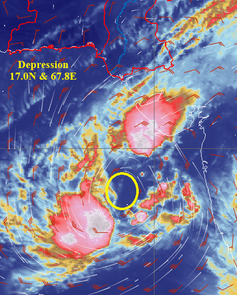
Depression over eastcentral Arabian Sea
The Depression over eastcentral Arabian Sea moved northeastwards during past 24hours and now lay centered around Latitude 17.00N & Longitude 67.80E at about 880Km south-southeast of Karachi and 510Km west-southwest of Veraval, Gujrat (India).
It is likely to move nearly north-northeastwards across eastcentral Arabian Sea during next 24hours.
Under its influence light rain/drizzle may occur in southeastern parts of Tharparker District.
Currently, there is no threat to any Pakistani coastal area. PMD’s cyclone warning center, Karachi is monitoring the system and will keep the relevant quarters abreast.
Issued By: Tropical Cyclone Warning Centre, Karachi
Issue Date: 27 October, 2025 11:42 AM |
Depression over eastcentral Arabian Sea
The Depression over eastcentral Arabian Sea moved north-northwestwards during past 24hours and now lay centered around Latitude 16.10N & Longitude 66.80E at about 970Km south-southwest of Karachi and 720Km west-southwest of Mumbai (India).
It is likely to move nearly northeastwards across eastcentral Arabian Sea during next 24hours.
Under its influence light rain/drizzle may occur in southeastern parts of Tharparker District.
Currently, there is no threat to any Pakistani coastal area. PMD’s cyclone warning center, Karachi is monitoring the system and will keep the relevant quarters abreast.

Issued By: Tropical Cyclone Warning Centre, Karachi
Issue Date: 26 October, 2025 11:25 AM |
Depression over eastcentral Arabian Sea
The Depression over eastern Arabian Sea moved northwestwards during past 12hours and now lay centered around Latitude 16.50 N & Longitude 66.80 E at about 936Km south-southeast of Karachi and 700Km west-southwest of Mumbai (India) over easterncentral Arabian Sea
It is likely to move nearly northwestwards across eastcentral Arabian Sea during next 24hours
Currently, there is no threat to any Pakistani coastal area. PMD’s cyclone warning center, Karachi is monitoring the system and will keep the relevant quarters abreast
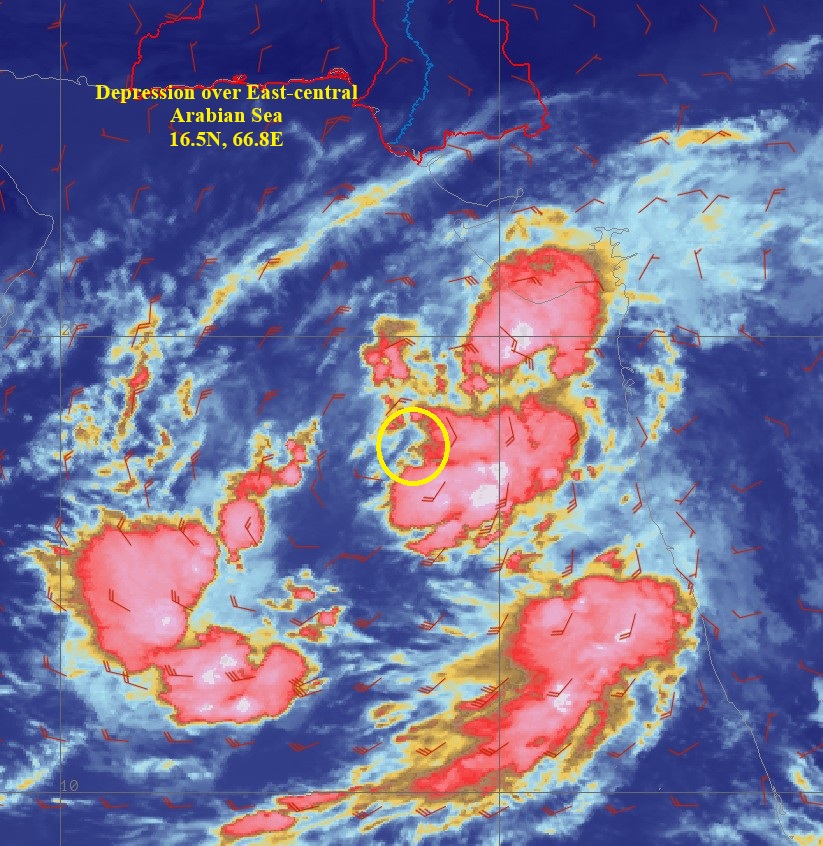
Issued By: Tropical Cyclone Warning Centre, Karachi
Issue Date: 25 October, 2025 12:06 PM |
Depression over eastcentral Arabian Sea
The Depression over eastern Arabian Sea moved north-northwestwards during past 24hours and now lay centered around Latitude 16.40 N & Longitude 70.40 E at about 1004Km south-southeast of Karachi and 400Km southwest of Mumbai (India) over easterncentral Arabian Sea.
It is likely to move nearly northwestwards across eastcentral Arabian Sea during next 24hours.
Currently, there is no threat to any Pakistani coastal area. PMD’s cyclone warning center, Karachi is monitoring the system and will keep the relevant quarters abreast.
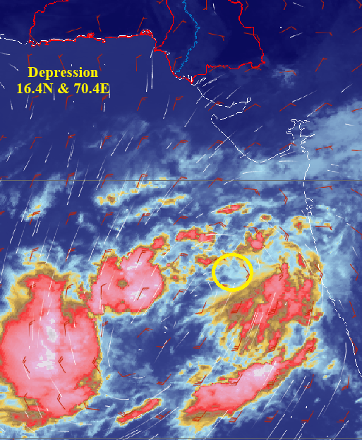
Issued By: Tropical Cyclone Warning Centre, Karachi
Issue Date: 24 October, 2025 11:16 AM |
Depression over southeast Arabian Sea
The Depression over southeast Arabian Sea moved north-northeastwards during past 24hours and lay centered around Latitude 13.3N & Longitude 70.5E at about 1340Km south-southeast of Karachi and 340Km northwest of Lakshadweep (India) over eastern Arabian Sea.
It is likely to move nearly north-northeastwards across eastcentral Arabian Sea during next 24hours.
Currently, there is no threat to any Pakistani coastal area. PMD’s cyclone warning center, Karachi is monitoring the system and will keep the relevant quarters abreast.
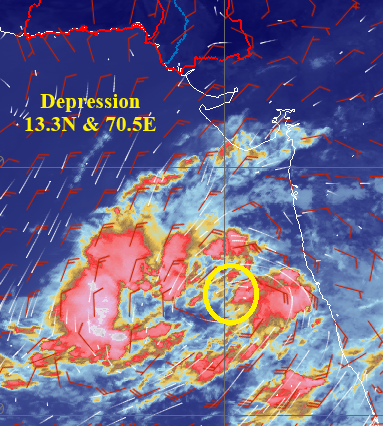
Issued By: Tropical Cyclone Warning Centre, Karachi
Issue Date: 23 October, 2025 11:15 AM |
Depression over southeast Arabian Sea
The Depression over southeast Arabian Sea moved slowly in north-northeast direction during past 24hours and lay centered around Latitude 9.7N & Longitude 67.7E at about 1690Km south-southeast of Karachi and 570Km west-southwest of Lakshadweep (India).
It is likely to move nearly Northeastwards during next 24hours.
Currently, there is no threat to any Pakistani coastal area. PMD’s cyclone warning center, Karachi is monitoring the system and will keep the relevant quarters abreast.
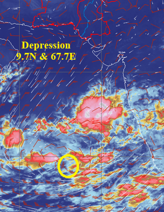
Issued By: Tropical Cyclone Warning Centre, Karachi
Issue Date: 22 October, 2025 03:41 PM |
Depression over southeast Arabian Sea
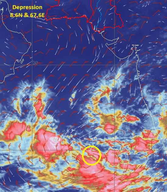
A well low-pressure area (WML) over southeast Arabian Sea has intencified into depression and lay centered around Latitude 8.6N & Longitude 67.6E at about 1800Km south-southeast of Karachi and 630Km west-southwest of Lakshadweep (India).
It is likely to move slowly North-Northwestwards during next 24hours.
Currently, there is no threat to any Pakistani coastal area. PMD’s cyclone warning center, Karachi is monitoring the system and will keep the relevant quarters abreast.
Issued By: Tropical Cyclone Warning Centre, Karachi
Issue Date: 6 October, 2025 06:41 PM |
Cyclonic Storm “SHAKHTI†Over Northwest Arabian SeaArabian sea
The cyclonic storm “SHAKHTI†over westcentral & adjoining northwest of Arabian Sea remained at same position and lay centered around Latitude 19.6◦N & Longitude 60.5◦E at about 900km southwest of Karachi.
It is likely to move east-southeastwards over the same region and weaken into a depression by next 12 hours.
Sea condition is likely to remain high to very rough over the same region with squally winds 45-55 gusting 65Km/hour into deep sea. Fishermen are advised not to venture into deep sea till 7th October morning and improve thereafter.
Gale wind speed reaching 70-80 gusting to 90Km/hour around the system center then it would gradually decrease becoming 45-55 gusting to 65Km/h during next 12 hours. Thereafter gradually reduce around the system center.
PMD’s Cyclone Warning Center, Karachi is monitoring the system and will issue the updates accordingly. The concerned authorities are requested to keep them abreast through PMD advisory.

Issued By: Tropical Cyclone Warning Centre, Karachi
Issue Date: 6 October, 2025 11:59 AM |
Cyclonic Storm “SHAKHTI†Over Northwest Arabian Sea
The severe cyclonic storm “SHAKHTI†over westcentral & adjoining northwest of Arabian Sea has weakened into cyclonic storm during last 06 hours and now lay centered at around Latitude 19.6◦N & Longitude 60.4◦E at about 910km southwest of Karachi.
It is likely to move east-southeastwards over the same region and weaken into depression by next 24 hours.
Under its influence, Isolated light rain likely to occur in coastal areas of Sindh & Balochistan today.
Sea conditions are likely to remain high to very rough with squally winds 70-90 gusting 90Km/hour near Sindh coast. Fishermen are advised not to venture into deep sea till 7th October and improve thereafter.
Gale wind speed reaching 80-90 gusting to 100Km/hour around the system center then it would gradually decrease becoming 45-55 gusting to 65Km/h with sea conditions are likely to remain very rough to high then very high over Northwest & West-Central Arabian Sea during next 24 hours. Thereafter gradually reduce around the system center.
PMD’s Cyclone Warning Center, Karachi is monitoring the system and will issue the updates accordingly. The concerned authorities are requested to keep them abreast through PMD advisory.

Issued By: Tropical Cyclone Warning Centre, Karachi
Issue Date: 6 October, 2025 11:19 AM |
Cyclonic Storm “SHAKHTI†Over Northwest Arabian Sea
The severe cyclonic storm “SHAKHTI†over westcentral & adjoining northwest of Arabian Sea has weakened into cyclonic storm during last 06 hours and now lay centered at around Latitude 19.6°N & Longitude 60.4°E at about 910km southwest of Karachi.
It is likely to move east-southeastwards over the same region and weaken into depression by next 24 hours.
Under its influence, Isolated light rain likely to occur in coastal areas of Sindh & Balochistan today.
Sea conditions are likely to remain high to very rough with squally winds 70-90 gusting 90Km/hour near Sindh coast. Fishermen are advised not to venture into deep sea till 7th October and improve thereafter.
Gale wind speed reaching 80-90 gusting to 100Km/hour around the system center then it would gradually decrease becoming 45-55 gusting to 65Km/h with sea conditions are likely to remain very rough to high then very high over Northwest & West-Central Arabian Sea during next 24 hours. Thereafter gradually reduce around the system center.
PMD’s Cyclone Warning Center, Karachi is monitoring the system and will issue the updates accordingly. The concerned authorities are requested to keep them abreast through PMD advisory.

Issued By: Tropical Cyclone Warning Centre, Karachi
Issue Date: 5 October, 2025 11:59 AM |
Severe Cyclonic Storm “SHAKHTI†Over Northwest Arabian Sea
The severe cyclonic storm “SHAKHTI†over northwest Arabian Sea has moved west-southwestwards during past 06 hours and now lay centered at around Latitude 21.0N & Longitude 61.8E at about 700km southwest of Karachi.
It is likely to move west-southwestwards by 6th October then it will recurve and move eastwards over west-central and northeast Arabian Sea subsequent 24hours and weaken gradually.
Under its influence, Isolated light rain likely to occur in coastal areas of Sindh & Balochistan today.
Sea conditions are likely to remain rough to very rough with squally winds 40-50 gusting 55Km/hour near Sindh coast. Fishermen are advised not to venture into deep sea till 5th October.
Gale wind speed reaching 110-120 gusting to 135Km/hour around the system center till afternoon of today then further decrease to 80-90 gusting to 100Km/hour for next 12 hours then gradually decrease becoming 50-60 gusting to 70Km/h with sea conditions are likely to remain very rough to high then very high over Northwest & West-Central Arabian Sea during next 36 hours. High to very high from midnight of 5th October to 7th October. Thereafter very rough to high around the system center.
PMD’s Cyclone Warning Center, Karachi is monitoring the system and will issue the updates accordingly. The concerned authorities are requested to keep them abreast through PMD advisory.

Issued By: Tropical Cyclone Warning Centre, Karachi
Issue Date: 4 October, 2025 09:16 PM |
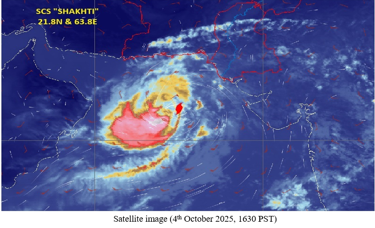
Severe Cyclonic Storm 'SHAKHTI' Over Northeast Arabian Sea
The severe cyclonic storm “SHAKHTI†over northeast Arabian Sea has moved west-southwestwards during past 06 hours, over the same region and now lay centered at around Latitude 21.8N & Longitude 63.8E at about 480km southwest of Karachi.
It is likely to move west-southwestwards and reach northwest and adjoining central north Arabian Sea by 5th October then it will recurve and move east-northeastwards subsequent 24hours and weaken gradually. Under its influence, Isolated light rain likely to occur in Badin, Thatta, Sujawal, Hub, Lasbella, Awaran, Keach districts today.
Sea conditions are likely to remain rough to very rough with squally winds 40-50 gusting 55Km/hour near Sindh coast. Fishermen are advised not to venture into deep sea till 5th October.
Gale wind speed reaching 100-110 gusting to 125Km/hour around the system center till evening of today then further increase to 110-120 gusting to 135Km/hour for next 12 hours then gradually decrease becoming 80-90 gusting to 100Km/h with sea conditions are likely to remain very rough to high then very high over central & North Arabian Sea during next 36 hours. High to very high from midnight of 5th October to 7th October. Thereafter very rough to high around the system center.
PMD’s Cyclone Warning Center, Karachi is monitoring the system and will issue the updates accordingly. The concerned authorities are requested to keep them abreast through PMD advisory.
Issued By: Tropical Cyclone Warning Centre, Karachi
Issue Date: 4 October, 2025 11:49 AM |
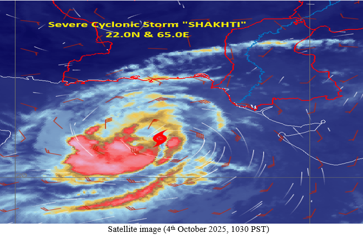
Cyclonic Storm 'SHAKHTI' Over Northeast Arabian Sea
The cyclonic storm “SHAKHTI†over northeast Arabian Sea has moved westward during past 12 hours, further intensified into severe cyclonic storm over the same region and now lay centered at around Latitude 22.0N & Longitude 65.0E at about 390km south-southwest of Karachi.
It is likely to move west-southwestwards and reach northwest and adjoining central north Arabian Sea by 5th October then it will recurve and move east-northeastwards during subsequent 24hours and weaken gradually.
Under its influence, Wind-Thunderstorm/rain of light to moderate intensity likely in Badin, Thatta, Sujawal, Jamshoro, Hub, Lasbella, Awaran, Keach, districts and at isolated places in Karachi Division today.
Sea conditions are likely to remain rough to very rough with squally winds 40-50 gusting 55Km/hour near Sindh coast. Fishermen are advised not to venture into deep sea till 5th October.
Gale wind speed reaching 90-100 gusting to 110Km/hour around the system center till evening of 4th October then further increase to 100-110 gusting to 125Km/hour for next 36 hours then gradually decrease becoming 70-80 gusting 90Km/h with sea conditions are likely to remain very rough to high then very high over central north & North Arabian Sea during next 36 hours. Thereafter very rough to high around the system center.
PMD’s Cyclone Warning Center, Karachi is monitoring the system and will issue the updates accordingly. The concerned authorities are requested to keep them abreast through PMD advisory.
Issued By: Tropical Cyclone Warning Centre, Karachi
Issue Date: 3 October, 2025 05:40 PM |
Cyclonic Storm 'SHAKHTI' Over Northeast Arabian Sea
The depression over northeast Arabian Sea has moved northwestward during past 06 hours, intensified into a cyclonic storm “SHAKHTI†over the same region and now lay centered at around Latitude 21.7N & Longitude 66.8E at about 360km south of Karachi.
It is likely to move west-northwestwards initially and likely to further intensify into severe cyclonic storm during next 24 hours. Thereafter it is likely to move west-southwestwards and reach over central north Arabian Sea.
Under its influence, Wind-Thunderstorm/rain of light to moderate intensity likely in Tharparker, Umerkot, Badin, Thatta, Sujawal, Tando Muhammad Khan, Hyderabad, Matiari, Shaheed Benazirabad, Sanghar, Jamshoro, Hub, Lasbella, Awaran, Keach, districts and at isolated places in Karachi Division today & tomorrow.
Sea conditions are likely to remain rough to very rough with squally winds 40-50 gusting 55Km/hour near Sindh coast. Fishermen are advised not to venture into deep sea till 5th October.
Gale wind speed reaching 65-75 gusting to 85Km/hour around the system center till evening of 4th October then further increase to 100-110 gusting to 125Km/hour with sea conditions are likely to remain very rough to high then very high over central north & North Arabian Sea during 3rd to 6th October.
PMD’s Cyclone Warning Center, Karachi is monitoring the system and will issue the updates accordingly. The concerned authorities are requested to keep them abreast through PMD advisory.

Issued By: Tropical Cyclone Warning Centre, Karachi
Issue Date: 3 October, 2025 10:52 AM |
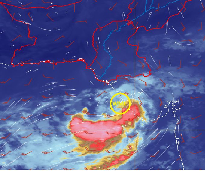
The Depression over Northeast Arabian Sea
The well-marked low-pressure area (WML) over northeast Arabian Sea and adjoining Saurashtra coast, Gujrat (India) has slowly moved west-southwestward during last 12 hours intensified into depression and now lies at around Latitude 21.0N & Longitude 67.9E at about 440km south of Karachi. The system is likely to move southwestwards towards northwest Arabian Sea during couple of days.
Under its influence, Wind-Thunderstorm/rain of light to moderate intensity likely in Tharparker, Umerkot, Badin, Thatta, Sujawal, Tando Muhammad Khan districts and at isolated places in Karachi Division today.
Sea conditions are likely to remain rough with squally winds 40-50 Km/hour near Sindh coast. Fishermen of Sindh are advised not to venture into deep sea till 3rd October.
Squally winds reaching 45-55 gusting to 65Km/hour around the system center with sea conditions are likely to remain rough to very rough over central-west central Arabian Sea during next couple of days.
PMD’s cyclone warning center, Karachi is monitoring the system and will issue the update accordingly. The concerned authorities are requested to keep them abreast through PMD advisory.

Issued By: Tropical Cyclone Warning Centre, Karachi
Issue Date: 1 October, 2025 12:05 PM |
Well Marked Low-pressure Area over Saurashtra coast, Gujrat (India)
The well-marked low-pressure area (WML) over Saurashtra coast and adjoining Gulf of Kuch, Gujrat (India) has moved westward and now lay over northeast Arabian Sea and adjoining Saurashtra coast, Gujrat (India) about 310Km southeast of Karachi. The system is likely to move westwards, intensify further into a depression during next 12hours over northeast Arabian Sea and move initially in west/southwest direction. Under its influence, Wind-Thunderstorm/rain of light to moderate intensity likely in Tharparker, Umerkot, Sanghar, Mirpurkhas, Badin, Hyderabad, Jamshoro, Thatta, Sujawal, Tando Muhammad Khan, Tando Allayar, Matiari districts and Karachi Division today. Sea conditions are likely to remain rough/very rough with squally winds 45-55 Km/hour. Fishermen of Sindh are advised not to venture into deep sea till 3rd October. PMD’s cyclone warning center, Karachi is monitoring the system and will issue the update accordingly. The concerned authorities are requested to keep them abreast through PMD advisory.
Issued By: Tropical Cyclone Warning Centre, Karachi
Issue Date: 30 September, 2025 11:52 AM |
Well Marked Low-pressure Area over Saurashtra, Gujrat (India)
The well-marked low-pressure area (WML) over Gulf of Cambay and adjoining Gujrat (India) has moved west northwestward and now lay over Saurashtra, Gujrat (India) about 340Km southeast of Karachi. The system is likely to move west/southwestwards & emerge into northeast Arabian Sea along Gulf of Kuch by late night/ tomorrow morning.
Due to favorable environmental conditions, sea surface temperature, low/moderate vertical wind shear and upper-level divergence, the system is likely to intensify further into a depression by tomorrow and move initially in west/southwest direction.
Under its influence, Wind-Thunderstorm/rain of light to moderate intensity likely in Tharparker, Umerkot, Sanghar, Mirpurkhas, Badin, Shaheed Benazirabad, Nosheroferoz, Hyderabad, Jamshoro, Thatta, Sujawal, Tando Muhammad Khan, Tando Allayar, Matiari districts and Karachi Division today and tomorrow.
Sea conditions are likely to remain rough/very rough with squally winds 45-55 Km/hour. Fishermen of Sindh are advised not to venture into deep sea till 2nd October.
PMD’s cyclone warning center, Karachi is monitoring the system and will issue the update accordingly. The concerned authorities are requested to keep them abreast through PMD advisory.

Issued By: Tropical Cyclone Warning Centre, Karachi
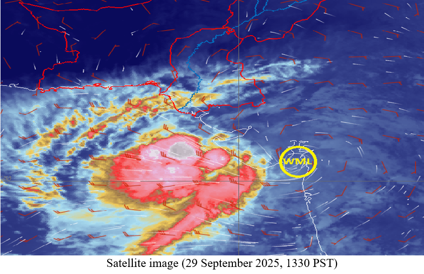
Issue Date: 29 September, 2025 02:40 PM |
Well Marked Low-pressure Area over Gulf of Cambay (India)
A well low-pressure area (WML) has lay over Gulf of Cambay and adjoining Gujrat (India). It is likely to move West-Northwestwards and emerge into Northeast Arabian Sea around Ist October 2025 near Saurashtra India.
There is a possibility of its intensification into depression around the time of emergence into the Northeast Arabian Sea.
Currently, there is no threat to any Pakistani coastal area. PMD’s cyclone warning center, Karachi is monitoring the system and will keep the relevant quarters abreast.
Issued By: Tropical Cyclone Warning Centre, Karachi
Issue Date: 24 May, 2025 11:33 AM |
Depression over East-Central Arabian Sea
The well-marked low pressure area (WML) over East-Central Arabian Sea has intensified into depression and lay centered around latitude 17.1 N, longitude 73.0 E, which is about 1058 km southeast of Karachi.
It is likely to move eastwards and cross Indian coast near Konkan around mid-day.
Currently, there is no threat to any Pakistani coastal area.
This is the last watch in this regard.

Issued By: Tropical Cyclone Warning Centre, Karachi
Issue Date: 23 May, 2025 11:14 AM |
Well-Marked Low-pressure Area over East-Central Arabian Sea
Intensification of Low Pressure Area (LPA) over East-Central Arabian Sea
The low-pressure area (LPA) over East-Central Arabian Sea has intensified into a well-marked low pressure area (WML) and lay around latitude 17.7 N, longitude 72.5 E, which is about 985 km southeast of Karachi.
Due to favorable environmental conditions, the system is likely to intensify further into a Depression (strong LPA) during next 24 hours and is expected to move initially towards north.
Currently, there is no threat to any Pakistani coastal area. PMD’s Cyclone Warning Center, Karachi is monitoring the system and will keep the relevant quarters abreast.

Issued By: Tropical Cyclone Warning Centre, Karachi
Issue Date: 22 May, 2025 11:14 AM |
Low-pressure Area Formed over Eastcentral Arabian Sea
A low-pressure area (LPA) has formed over East-Central Arabian Sea at around latitude 16.4 N, longitude 71.9 E, which is about 1075 km southeast of Karachi.
Due to favorable environmental conditions, the system is likely to intensify further into a Depression (strong LPA) during next 36 hours and expected to move initially towards north.
Currently, there is no threat to any Pakistani coastal area. PMD’s cyclone warning center, Karachi is monitoring the system and will keep the relevant quarters abreast.

Issued By: Tropical Cyclone Warning Centre, Karachi
Issue Date: 21 May, 2025 02:36 PM |
Formation of low pressure area (LPA) over East central Arabian Sea during next 12 hours
Formation of Low Pressure Area (LPA) over East-central Arabian Sea
The upper air cyclonic circulation extending up to mid-tropospheric level over East-central Arabian Sea off North Karnataka-Goa coasts (India).
Under its influence, a low-pressure area is likely to form over the same region during next 12 hours. Thereafter, it is likely to move nearly northwards and intensify further into a depression during subsequent 36 hours.
PMD’s Cyclone Warning Center, Karachi is closely monitoring the system and will issue the update accordingly. The concerned authorities are requested to keep themselves abreast through PMD advisory.
