Tropical Cyclone History for Karachi
Dr. Qamar-uz-Zaman Chaudhary
Let not the cyclone haunt us. Better scare it away. Away from our minds. But we still have to be mindful of the facts about cyclones. The facts however, remain that each year before the onset of monsoon (15 April to 15 July) and also after its withdrawal (15th September to 15th December), there is always a distinct possibility of the cyclone storm to develop in the north Arabian Sea.
The word “cyclone” is of Greek origin and means a “coil of snake”. No doubt, fully developed cyclone not only resemble the coil of the snake they have the venom of thousands of snakes as far as there killing capability is concerned. These giants kill in three ways-by coursing heavy to very heavy continues down pour leading to floods strong to very strong sustained winds, and tidal waves. The distinguishing property of the cyclonic storm is, however, the onslaught of tidal waves with often a company the storms along with strong sustained winds and torrential rain.
Tropical cyclone are classified according to the maximum winds which a company them as indicated in the following.
Depression – winds up to 33 Knots, Cyclonic Storm – winds from 34 to 47 Knots, Severe Tropical Strom – Winds from 48 to 63 Knots, Hurricane – winds of 64 Knots or more.
The major killing factor is there for the tidal wave assisted by very strong winds as regards tidal waves possible coincidence of the time of passage of an expected cyclonic storm with high and low tide times and loner dates can appreciably add her decrees the actual heights of the tidal waves.
This important factor is, therefore, given due consideration when forecasting the passage of the cyclonic storm into the costal areas.
It is worthwhile to evaluate how great is the danger of cyclonic storm striking Karachi or other costal areas of Pakistan. Because of its very high population and industrial growth, Karachi merits special attentions. Although nobody except providence knows what fate awaits us, the changing natural processes and events do provide a clue to us. One of the parameter utilized by Meteorologist is the climatology or past records of weather events.
In this connection meteorological data about the cyclonic storms in the north Arabian sea is available for more then a century. During the last 100 years a number of cyclonic storms have struck Pakistan’s costal areas.
The years involved were 1895, 1902, 1907, 1948, 1964 and 1985.
The cyclonic storm in 1964 which actually enter the Indian coast did cause the great loss of life and property in Hyderabad and Tharparkar districts as it moved north east ward into south eastern areas of Sindh. It is strange that three cyclonic storms – two in the year 1902 (13th May & 16th June) and one in 1907 (6th June) stuck the coast in the vicinity of Karachi during a short span of six year? The other two cyclonic storms in the years 1895 and 1984 struck the Mehran cost near Pasni and Jiwani respectively.
The cyclonic storm in 1985 which moved was Karachi actually had weakened over the sea while still a few 100 Kilometers away south of Karachi. It did, however, cause concern and panic for Karachiites.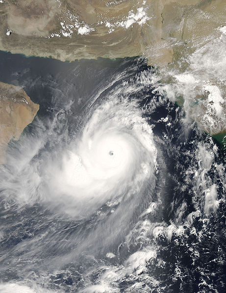
The Gonu 2007
Cyclone Gonu 2007 , Super Cyclonic Storm Gonu is the strongest tropical cyclone on record in the Arabian Sea and is also the strongest named cyclone in the northern Indian Ocean. The second named tropical cyclone of the 2007 North Indian Ocean cyclone season, Gonu developed from a persistent area of convection in the eastern Arabian Sea on June 1. With a favorable upper-level environment and warm sea surface temperatures, it rapidly intensified to attain peak winds of 240 km/h (150 mph) on June 3. Gonu weakened after encountering dry air and cooler waters and early on June 6, it made landfall on the eastern-most tip of Oman, becoming the strongest tropical cyclone to hit the Arabian Peninsula. It then turned northward into the Gulf of Oman, and dissipated on June 7 after making landfall in southern Iran.
The Yemyin 2007
On June 21st, the Indian Meteorological Department declared (IMD) the low pressure area into depression 430 Km East South East of Kakinada, Andhra Pardash India. After several hours joint typhoon Warning centre (JTWC) issued a tropical cyclone formation alert (TCFA) with wind 55 Km per hour. the depression moved quickly West-North West toward the northern Andhra Pardash coast. A subtropical ridge to the north weakened the wind share which had been paralyzing the system allowing for further intensification. After that day the (IMD) upgraded the system to deep depression. The JTWC issued the first warning on tropical cyclone 03B. The final warning was issued on 24th June, despite the storm having moved into Arabian Sea.
Early on June 25th the (JTWC) issued the second TCFA for this system. Pakistan Meteorological Department (PMD) resumed advisories on the depression. As it moved North West just off the Pakistan coast winds of about 48 Km/h and a surface pressure of 990 mbar were observed in Karachi near midday on June 25. According to Pakistan Meteorological Department (PMD) the center of the system reached within 90Km of Karachi. With favourable conditions and deep convection the system intensified into deep depression that day. After further Organization it made its landfall at about 0300 UTC along the Makran coast, near Ormara & Pasni, Balochistan Province, in South Western Pakistan. On reaching land the cyclone began to weaken slowly and Pakistan Meteorological Department (PMD) issued its last advisory late on 26th June.
The Phet 2010
Super Tropical Cyclone Phet (which is thai word pronounced as Pet meaning diamond) was the third named cyclone of 2010 North Indian ocean cyclone season.
It started forming from low pressure area in the central Arabian sea near 15N 64E and intensified into a tropical cyclone on 1st June 2010. Initially it was located at about 1100 km south-southwest of Karachi and moved in north westerly direction with a speed of 6 knots. On 31st May Tropical cyclone warning centre of Pakistan Meteorological Department warned fishermen of Sindh and balochistan not to venture in open sea during next 6-8 days. On 3rd june Phet struck North-Eastern oman coast and downgraded to severe tropical cyclone. On 4th June it started recurving Northeastward towards Pakistan coast as was expected. Tropical cyclone made a land fall on 6th June along Sindh coast ( between Karachi and Keti bunder) and weaken rapidly into a well marked low pressure area on 7th June.
Pakistan coastal areas were impacted by storm surge of 12 to 14 feet high and torrential rains occurred along Sind-Makran coast. Gawadar received 370mm rainfall whereas Jiwani 208, Pasni 130, Karachi (Masroor) 150 and Karachi (Faisal) 122. |