|
Flash Floods in Sindh;
An evidence of climate variability in the region Azmat Hayat Khan* |
Following
a severe drought, most parts of Sindh experienced a prolonged siege of moderate
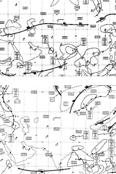
to heavy rainfall. This included very heavy downpour on July 26 in 700 hpa chart of
activities in the area. This
rainfall event also led to lo
Antecedent Conditions
 The winter of
2003 saw the end of an El Nino cycle that persisted for the four months prior
to the onset of the heavy rains in
The winter of
2003 saw the end of an El Nino cycle that persisted for the four months prior
to the onset of the heavy rains in
As June began, a series of strong synoptic storms
brought heavy rain to the northern half of country, caused by a clash of
unseasonably cool air coming south from Ru
Main features during the
event
By the beginning of July, a trough had developed in
the northeast
·
The strong
persistent jet stream created a quasi-stationary boundary that established an
overall cyclonic circulation which provided a favorable environment for
developing weather systems.
·
A delay in the
onset of the SW Monsoon season over subcontinent provided a longer period of an
environment favorable to convective precipitation. Monsoon season was nearly
one week delayed over central parts of 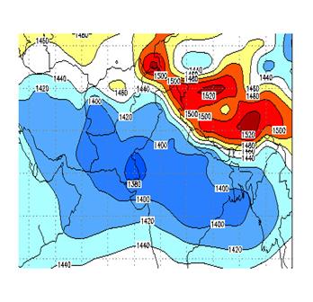
Perhaps
the most remarkable aspect behind the recent flash floods was the frequency and
intensity of the Mesoscale Convective Complexities
that provided much of the rainfall during July.
MCC’s are quasi-circular thunderstorm
complexes covering an area greater than 50,000 square km and lasting in
duration over six hours (Anderson, C. and Arritt, W.,
1998). The complexes initiate in the
afternoon and reach their peak overnight.
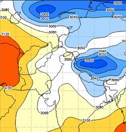
The persistent trough in central
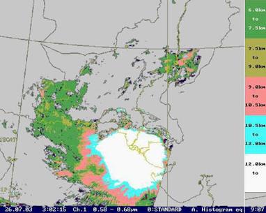
Moisture feeding at 850hpa level over gangatic plains and southern parts of HRPT cloud height
analysis depicting that weather system had developed to a great depth.
 The typical
flash flood environment had abundant moisture through a great depth of the
atmosphere. Low values of vertical wind shear were present resulting to
moisture convergence over the area. Flash flooding was mainly produced by
"train effect" storms. A number of multi-cell cluster storms were
present which favoured the development of train
effect storms over the area.
The typical
flash flood environment had abundant moisture through a great depth of the
atmosphere. Low values of vertical wind shear were present resulting to
moisture convergence over the area. Flash flooding was mainly produced by
"train effect" storms. A number of multi-cell cluster storms were
present which favoured the development of train
effect storms over the area.
The upper level winds are the "steering current" for convective
storms. It is the jet stream that powers the upper level winds. Jet streaks
within the jet stream cause air, which is closer to the surface of the earth,
to rise due to a vacuum effect the jet streaks create. As a jet streak enters
into a trough, it can energize the trough causing the low pressure to deepen
and heights to fall.
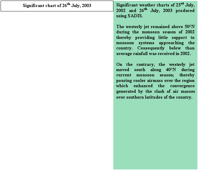
Significant chart of
A totally
different development arises when the easterly jet moves farther north than
usual because the monsoonal wind rising over the southern slopes of the
Storm precipitation intensities and damages caused.
Heavy downpour during
the last weak of July 2003 was recorded at a number of places in southeast
Sindh causing damages to loss of life and property. First spell of heavy rains hit the area on 8th
July and Larkana; a city in central parts of Sindh
received 209mm of rainfall in 24 hrs. 50 to 80 mm of rainfall was also received
in other localities of Sindh during the period. Again the system hit lower
Sindh and coastal areas of country on
The system
reached its climax on 25th July and most of lower Sindh including
metropolitan city of
|
STATION |
TOTAL Rainfall (mm) |
|
|
|
264.7 |
85.5 |
|
|
253.3 |
66.4 |
|
|
256 |
67 |
|
|
213.3 |
67 |
|
|
183.5 |
85 |
|
|
98.6 |
85 |
|
|
204 |
56.7 |
|
Chhor |
403.6 |
79 |
|
Badin |
294.4 |
70.5 |
|
Jacobabad |
97.9 |
36.8 |
|
Rohri |
40.3 |
25.7 |
|
Larkana |
222.3 |
|
|
Nawabshah |
281.1 |
51.8 |
|
Thatha |
435 |
71 |
|
Diplo |
156 |
|
|
Mithi |
156 |
|
|
Chachro |
110 |
|
|
Nagar Parker |
97 |
|
|
Keti Bander |
61 |
|
|
Shah Bander |
30 |
|
|
Mir Pur Pathoro |
154 |
|
|
Sajawal |
60 |
|
|
Jati |
60 |
|
Hundreds of
villages of lower Sindh were affected by flash floods. Detail of damages as
reported by Relief Commissionorate, Sindh is appended
below.
|
Damages to infrastructure |
Losses of Human lives |
Animal deaths |
Damages to kharif crops |
||||
|
Pacca Houses |
Katcha houses |
||||||
|
Fully |
Partially |
Fully |
Partially |
Deaths |
Injured |
||
|
2000 |
3000 |
30,000 |
40,000 |
178 |
235 |
9455 |
·
Paddy 90% ·
Sugarcane 80% ·
Cotton 80% ·
Beatle Leaf 80% |
Conclusion
Increased
frequency of such weather extremes during last decade signals climate variability
in the region. The quantitative research of few aspects suggests that Pakistan experience
a Wet winter with decreasing intensity of La Nina (Sea Surface temperatures in
the Pacific Ocean becoming near normal) where as suppressive rainfall activity
during monsoon season is observed during strong El Nino event.
Moreover, preliminary
analysis using the current El Nino Southern Oscillation-related (ENSO)
sea-surface temperature anomalies in the tropical Pacific show a response that
replicates the observed precipitation and temperature anomalies to a noticeable
extent.
This
suggests that the current long-lived ENSO event affected atmospheric features
associated with the extreme weather events.
* Senior Meteorologist, R
& D